The wait is finally over for lakhs of travellers between Delhi and Dehradun. The Delhi Dehradun Expressway officially opened on April 14, 2026, after PM Narendra Modi inaugurated it. What once took six hours now takes just 2.5 hours. This change is not a small upgrade. It is a complete transformation of how North India travels.
If you are planning a drive from Delhi to Dehradun, this guide has everything you need. You will find the route map, route number, toll charges, speed limit, entry and exit points, and much more. Read it once before you hit the road.
What Is the Delhi Dehradun Expressway?
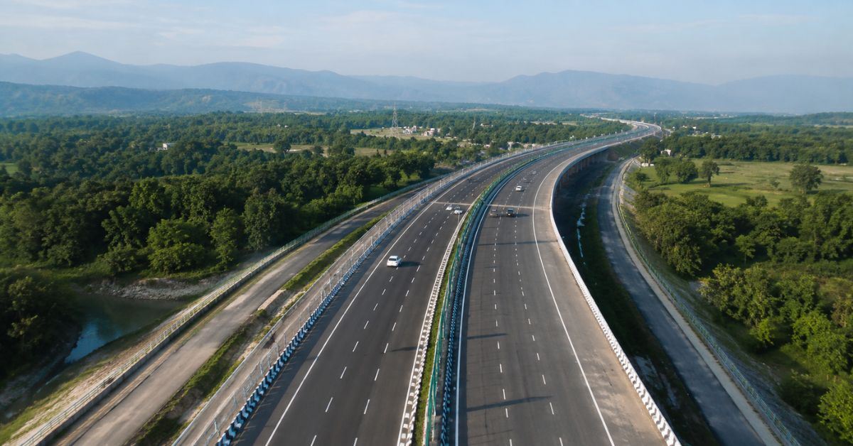
The Delhi-Saharanpur-Dehradun Expressway, also called the Delhi-Dehradun Economic Corridor, spans 210 km as a six-lane access-controlled highway expandable to eight lanes. NHAI developed it under the Bharatmala Pariyojana initiative using an Engineering, Procurement, and Construction contract model.
The expressway starts from Akshardham in Delhi and ends at Dehradun, connecting the two cities via Saharanpur. It connects three prime states: Delhi, Uttar Pradesh, and Uttarakhand. The expressway crosses key cities like Baghpat, Baraut, Shamli, and Saharanpur along the way.
The project was built at a cost of around Rs 12,000 crore and developed in four phases, blending greenfield and brownfield sections.
Delhi Dehradun Expressway Route Opening Date
Prime Minister Narendra Modi officially inaugurated the Delhi Dehradun Expressway on April 14, 2026, on the occasion of the Baisakhi festival. He also visited Saharanpur to review the wildlife corridor and performed a pooja at the Jai Maa Daat Kali Temple near Dehradun.
The project did not arrive overnight. The foundation stone of the project was first laid by Nitin Gadkari, Union Minister for Road Transport and Highways, on February 26, 2021, and was later inaugurated again by Prime Minister Narendra Modi on December 4, 2021.
The project faced several deadline revisions over the years. Despite those delays, construction progressed steadily. Trial runs began on the Delhi-Baghpat stretch in December 2025. By early 2026, the project stood at 98% completion. The final inauguration on April 14, 2026 delivered a world-class highway to millions of travellers.
Delhi Dehradun Expressway Route Number
The Delhi Dehradun Expressway carries the designation National Highway 709B. It integrates NH-709B, NH-307, and NH-344G, passing through Delhi, Baghpat, Baraut, Shamli, and Saharanpur in Uttar Pradesh, and into Uttarakhand.
Knowing the route number helps when you search on GPS devices or toll apps. Entering NH-709B gives you the correct alignment every time. This route number also appears on toll receipts and NHAI signage along the highway.
The 210 KM Route: Phase by Phase
The Delhi Dehradun Expressway direction runs from southeast to northwest. It originates at Akshardham in East Delhi and terminates at Asharodi near Dehradun. The route is organised into four distinct phases.
- Starting near Akshardham Temple in Delhi, the expressway heads to the Eastern Peripheral Expressway (EPE) junction near Khekra, covering around 32 km with a partly elevated section.
- Phase 2 runs from Baghpat to Saharanpur: a 118-km greenfield stretch that bypasses towns like Baraut and Shamli. This section keeps through traffic away from local congestion. Seven interchanges serve this stretch, including Mandola Vihar, Khekra, Lohadda, and Halgoya.
- Phase 3 connects Saharanpur to Ganeshpur at the edge of Rajaji National Park. This stretch transitions the highway from the plains of UP to the Uttarakhand foothills.
- Phase 4 covers a challenging 19.5-km eco-sensitive section: a 2.32-km twin-tube tunnel, a 4.82-km elevated flyover with 6-metre clearance for wildlife, a 2.12-km at-grade hill road, and a 340-metre single-tube tunnel near the Daat Kali Temple, ending in Dehradun.
Together, these four phases deliver a 210-km drive that covers plains, forests, hills, and tunnels.
Delhi Dehradun Expressway on Google Maps
Travellers can already find the Delhi Dehradun Expressway on Google Maps. When you search for directions from Delhi to Dehradun, Google Maps usually recommends this as the fastest available route. The expressway appears as a controlled-access highway through Baghpat and Saharanpur.
For the most accurate results, set your starting point as Akshardham or a nearby Delhi landmark. Select Dehradun as the destination. The map will display the expressway corridor clearly. You can switch to satellite view to see the elevated sections and the wildlife corridor near Rajaji National Park.
Keep in mind that Google Maps may still be updating toll plaza data for this new expressway. Always verify toll charges before you start your journey.
Delhi to Dehradun New Expressway Route Map PDF
The official route map for the Delhi Dehradun Expressway is available on the NHAI website at nhai.gov.in. The project documents section includes detailed alignment maps showing phase boundaries, interchanges, and spur connections.
Several state infrastructure portals and government-linked travel platforms also publish the Delhi to Dehradun new expressway route map PDF. These maps typically show all 16 entry and exit points, toll plaza locations, and service road alignments.
If you prefer an offline version for road trips, download the map from an official or credible source. This ensures you have the correct alignment, especially for the eco-sensitive section near Rajaji National Park where mobile networks may be patchy.
Delhi Dehradun Expressway Toll Charges
Knowing the toll charges helps you budget your trip accurately. The Delhi Dehradun Expressway uses a distance-based closed tolling model. This means the toll amount reflects the distance you actually travel.
There are five toll plazas on the Delhi-Dehradun Expressway, all FASTag-enabled. For cars and sedans, a one-way trip costs somewhere between Rs 670 and Rs 675, while a round trip completed within 24 hours may cost around Rs 1,000.
From April 10, 2026, all toll plazas on national highways, including the Delhi-Dehradun Expressway, accept only FASTag and UPI payments. Cash payment has been completely discontinued. Drivers without a valid FASTag will be charged double the standard toll rate under the penalty provisions.
Frequent commuters can opt for a FASTag annual pass that reduces the per-trip cost to approximately Rs 60. This is a smart option for those travelling between Delhi and Dehradun regularly.
Here is a quick toll breakdown by category:
Cars and sedans (one way): Rs 670 to Rs 675 Round trip within 24 hours: Approximately Rs 1,000 Vehicles without FASTag: Double the standard rate.
Always ensure your FASTag is active and loaded with at least Rs 1,000 before entering the expressway.
Delhi Dehradun Expressway Speed Limit
The Delhi-Dehradun Expressway has a 100 km/h speed limit for all light vehicles. This limit does not change officially across the entire stretch. Heavy vehicles follow lower speed norms as per standard NHAI rules.
The expressway is expected to carry approximately 20,000 to 30,000 vehicles per day at an average speed of 100 km/h. This volume requires strict speed discipline to prevent bottlenecks and accidents.
The visual cues of the wildlife corridor invite caution. Nighttime crossings by deer and elephants are documented in the Rajaji buffer zone. Slow down and stay alert when driving through this section after dark.
NHAI has installed speed cameras at regular intervals. Overspeeding will attract fines under the Motor Vehicles Act. Stick to 100 km/h and make your drive safe for yourself and the wildlife nearby.
Delhi Dehradun Expressway Entry and Exit Points
This highway boasts 16 entry and exit points, five railway overbridges, 113 road underpasses, 76 km service roads, 29 km elevated sections, and 62 bus shelters.
Key entry and exit points include Akshardham and Geeta Colony in Delhi, Loni and Mandola in the Ghaziabad and Baghpat area, Shamli Road for Muzaffarnagar-bound traffic, the Saharanpur Bypass, and Asharodi near Dehradun.
The expressway also connects with major highways. The Delhi Dehradun Expressway connects with NH-344, NH-58, and the Eastern Peripheral Expressway. This allows travellers from Noida, Ghaziabad, and Faridabad to enter the expressway without going all the way to Akshardham.
A dedicated 76-km service road runs parallel to the main carriageway. This road handles local traffic separately and prevents slow vehicles from merging with highway traffic.
The Rajaji National Park Wildlife Corridor
The wildlife corridor is the most celebrated feature of the Delhi Dehradun Expressway. The expressway features Asia’s longest elevated wildlife corridor in Rajaji National Park, spanning around 12 km.
The design of this section is remarkable. The elevated flyover provides a 6-metre vertical clearance for elephants and other wildlife, allowing them to move freely beneath the highway. Leopards, deer, and elephants all use the corridor below without any disturbance from traffic above.
NHAI has also installed noise barrier devices near the forest section. These reduce sound pollution and protect animals from stress caused by highway traffic. Water harvesting systems and fly ash usage during construction further support environmental goals.
This corridor demonstrates that ambitious infrastructure projects can coexist with nature conservation.
Spur Expressways: Connecting Haridwar, Roorkee, and Ambala
The Delhi Dehradun Expressway connects more than two cities. It includes a 50.7-km long six-lane Saharanpur-Roorkee-Haridwar Expressway as a spur, which will also connect to the Char Dham Highway. Pilgrims heading to Haridwar, Rishikesh, or the Char Dham circuit can now travel from Delhi in far less time.
The second spur is a 121-km Ambala-Shamli six-lane Expressway, connecting Uttar Pradesh with Haryana. This strengthens the regional highway network significantly.
Together, these spurs make the Delhi Dehradun Expressway a true regional transport hub, not just a city-to-city corridor.
How This Expressway Changes Your Journey
The numbers tell the story clearly. What used to be a six-hour grind on NH-7 through Modinagar, Muzaffarnagar, and Roorkee is now a 2.5-hour run on a 6-lane access-controlled corridor with a 100 km/h speed limit and zero traffic signals.
A real-world drive test in April 2026 clocked 2 hours and 28 minutes from Akshardham to Dehradun’s Asharodi exit on a weekday morning. That number would have sounded impossible five years ago.
Weekend trips to Mussoorie, Rishikesh, and Haridwar are now practical for Delhi families. Businesses can move goods faster between UP and Uttarakhand. Students commuting between the two cities no longer lose an entire day to travel.
Practical Tips Before You Drive
Plan your trip with these important points in mind:
- Keep your FASTag active and loaded before you enter the expressway. The minimum recommended balance is Rs 1,000.
- Follow the 100 km/h speed limit throughout the drive. Slow down near the Rajaji National Park section, especially after sunset.
- Fuel up in Delhi or Saharanpur since filling stations on the expressway are limited.
- Download an offline route map or save a screenshot before travelling through forest zones.
- Mobile network coverage may be unreliable near the Uttarakhand stretch.
- Check updated toll rates from NHAI before your trip since rates may be revised over time.
Final Thoughts
The Delhi Dehradun Expressway is one of the most significant road projects North India has seen in decades. The expressway is more than just a faster road. It is a genuine reimagining of how North India connects, from the capital’s eastern fringes to the shadow of the Himalayas.
It brings Haridwar, Rishikesh, and Mussoorie within easy reach from Delhi. It supports trade, tourism, and pilgrimage traffic on a scale that was not possible earlier. The wildlife corridor shows the world that India can build fast and build responsibly at the same time.
Whether you are heading out for a weekend break, a business meeting, or a Char Dham yatra, the Delhi Dehradun Expressway gives you a journey you will enjoy rather than endure.